
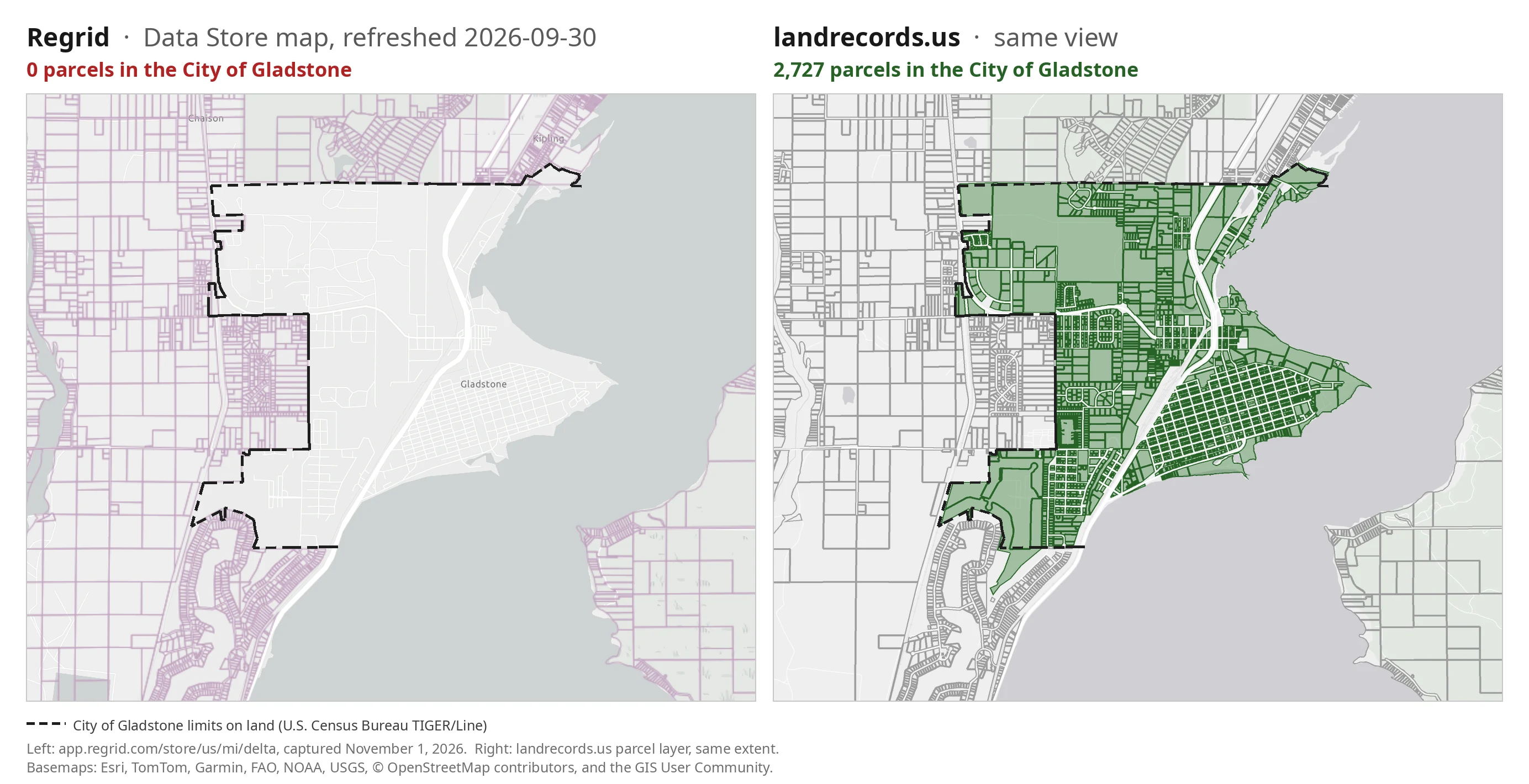
As of its September 30, 2026 refresh, Regrid’s data store lists 28,037 parcels for Delta County, Michigan. On the left above is that store page’s own map, zoomed in on the north end of Little Bay de Noc on November 1, 2026; on the right is the same view in our layer. Regrid’s parcel lines run up to the edge of the City of Gladstone on every side and then stop. Inside the city limits there is nothing: not a lot, not a line. Delta County has two cities, and one of them is missing from Regrid’s Delta file. Our Delta layer carries 2,727 parcels inside the City of Gladstone. Every one has an owner of record; together they belong to 2,292 owners and carry $197.9 million in assessed value.
One city, zero parcels
Gladstone covers about five square miles of the bay shore north of Escanaba. It has a downtown along Delta Avenue, a harbor, residential grids on both sides of US-2/41, a golf course, and a strip of lakefront homes. On Regrid’s map, all of that is basemap. In the comparison above, the dashed line is the city limits on land, from the U.S. Census Bureau, and our 2,727 Gladstone parcels are filled green.
These are not edge cases. They include the bank branches on the main street and the city’s largest commercial and lakefront properties. Each line below is a real Gladstone tax account, and none of them appears in Regrid’s Delta file:
052-616-032-10— 1100 N Lake Shore Drive, Miron Enterprises LLC, $2,937,600 assessed — the highest-assessed account in the city.052-629-010-00— Kenneally Boulevard, Lake Bluff Retirement Community LLC, $2,740,100 — golf-course land, sold for $3,195,000 on October 4, 2019.052-092-001-50— 1400 Delta Avenue, First Bank Upper Michigan, $674,900.052-302-001-00— 104 S 10th Street, BayBank, $544,100.052-621-010-00— 103 N 12th Street, DelFab Inc, $509,600.
| City of Gladstone, Delta County, MI | Regrid (refreshed 2026-09-30) | landrecords.us |
|---|---|---|
| Parcel records inside the city limits | 0 | 2,727 |
| Owners of record | 0 | 2,292 |
| Assessed value visible | $0 | $197.9 million |
| Parcels with a recorded last sale | 0 | 2,034 (most recent May 28, 2026) |
What the 2,727 missing records are
Gladstone assesses its own parcels, and every account carries a Michigan property class. Grouped by class:
| Property class | Parcels | Owners | Assessed |
|---|---|---|---|
| Residential — 1,861 improved homes, 440 vacant lots, and other residential classes | 2,512 | 2,141 | $167.3 M |
| Commercial | 188 | 155 | $26.3 M |
| Industrial | 21 | 14 | $4.2 M |
| Agricultural and unclassified | 6 | 4 | $0.1 M |
| Total | 2,727 | 2,292 | $197.9 M |
Michigan assesses property at half of its true cash value, so the market value behind those figures is roughly twice as large. Nearly 1,900 homes and almost 200 commercial parcels are not a rounding error. They are the city.
Why the city falls through
Delta County publishes a parcel map service, and it is a good one. But it draws the county’s fourteen townships, not its two cities: Michigan cities run their own assessing, and Gladstone and Escanaba keep their own parcel records. Every Gladstone parcel number begins with the city’s unit code, 052, and none of the county’s polygons carries one.
Gladstone publishes its parcels separately, through a city-run ColligoGIS portal rather than an ArcGIS service. A pipeline that harvests the county’s ArcGIS layer gets the townships and a hole where the city should be. Regrid’s July 2024 Delta file was 22,456 records, within 16 of the county’s township-only service. Their September 2026 refresh grew the county to 28,037 records and now draws Escanaba’s street grid, but Gladstone is still blank. According to the same store page, Owner Name is 79% populated and Parcel Address 71%.
What this is not
A claim that a competitor is missing an entire city is exactly the kind of claim we try to disprove before we publish it. The checks:
- Not a rendering glitch. The hole is there at every zoom level on Regrid’s store map, and it follows the city limits. The parcels of the surrounding townships draw right up to the Gladstone line and stop.
- Not our duplication. None of the city’s parcels shares a parcel number with the county’s township layer, and none sits on top of a county parcel. They are the city’s own records, drawn on ground the county layer leaves empty.
- Not outside the city. 2,724 of the 2,730 polygons in Gladstone’s layer fall inside the Census Bureau’s boundary for the City of Gladstone. The other six sit just over the line in Escanaba and Brampton Townships.
- Not stale. We acquired Gladstone’s layer from the city’s portal on October 28, 2026. Its most recent recorded sale is May 28, 2026.
Why our collection method found Gladstone
A county total is the wrong yardstick for a county where cities assess themselves. Our pipeline treats the jurisdiction that keeps the roll as the unit of collection, not the county map service:
- We collect from whoever keeps the roll. In Delta County that means the county’s township service and the City of Gladstone’s own ColligoGIS portal, harmonized into one parcel schema with the city’s parcel numbers, owners, values, and sales intact.
- Every parcel knows which city or township it is in. Each record carries its county subdivision, so a city with zero parcels shows up as a hole in our own coverage, not as a rounding error in a county total.
- We check against the assessor, not against other vendors. Measured as a county total against Regrid’s old 2024 count, our Delta layer read 112% and looked like over-coverage. Measured city by city against the assessors, it resolves into the City of Gladstone, present in ours and absent in theirs.
If your work touches Gladstone — ownership outreach, valuation, lending, title research, a site search on the north end of the bay — a dataset without the city isn’t showing you a thinner version of Delta County. It’s showing you a county in which 2,727 properties, 2,292 owners, and $197.9 million of assessed real estate don’t exist.
Delta County’s datasets, vintages, and per-field coverage are on its coverage page; compare us on coverage, fields, and price on our home page or browse the US Nationwide Parcel Dataset. Email hello@landrecords.us — we’re happy to run this same analysis for any county you care about.
So, what does "100% coverage" mean at Regrid, anyway?